We believe the last time the Denmark Mountain Hikers ascended to Champney Falls was just over a year ago on September 20, 2024.
The Champney Falls Trail is an old Bridle path that climbs at a moderate rate following Champney Brook for the initial part of the trail. At 1.4 miles a well-marked loop trail turns left to Champney and Pitcher Falls. This .4 mile trail took us up to the foot of Champney Falls, Pitcher Falls is further upstream to the left.(Pitcher Falls is a very popular ice climbing spot in the winter)
The loop trail climbs along champion Brook re-joining the champion Falls Trail at approximately 1.7 miles from the trail head and then continues back down to the parking lot.
Weather conditions for today’s hike were very nice. At the start, it was mid 30s mostly sunny with no wind and by the time we got to the Falls, the temperature had warmed into low the 40s and was mostly overcast and cloudy. By the time we returned the parking lot it was between 45 to 50. Still overcast no wind and I’m happy to say we beat any sprinkles and showers that developed shortly after we got back in the cars.
Seven Denmark Hikers along with the dogs, Ruby and Piper, met at the Denmark church and drove from there to the trail head for Champney Falls. In the parking lot were 11 more Denmark Hikers waiting.
We broke into two smaller groups, which is recommended by the AMC and other organizations to minimize the impact large groups can have on the environment and other hikers on the trail.
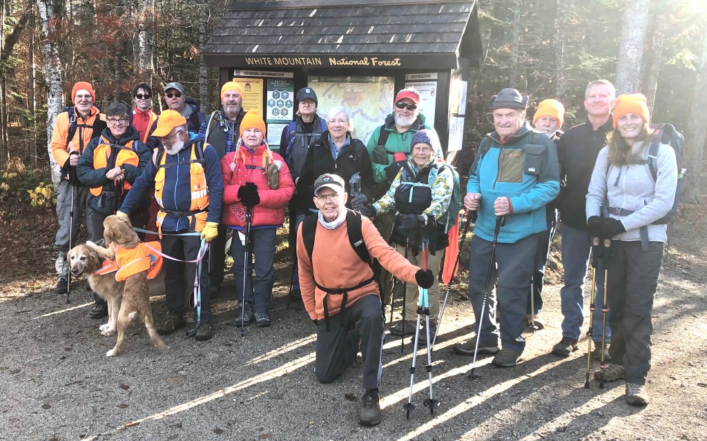
Hiking today were;
Jeffrey Sturgis, Tom Dugas, Jacob Schor, Greg Moulton, Tina Estes, Ray, and Carol, Strozewski, Gordon Farrell, Paul Waterhouse, Dale, and Kitty Nelson, Liz Hurd, David Atchason, Sandy Bell, Robin Marcello, Kathy Huchthausen, Ron Paquette, Susan Sedita, along with Jacob‘s, dogs, Ruby and now four -and -a- half -month-old Piper.
We took a group photo in the parking lot at approximately 9:35 AM. The first group promptly left followed by the second group about five minutes later. Along this hike, there are three significant water crossings on the approach to the falls. Several inches of rain earlier in the week resulted in our choo0sing the word significant in the prior sentence. Last year we might have described the water as insignificant. Or we coud have described the crossings as challenging nevertheless they were doable without serious mishaps. The climb is mostly gentle with about 700 feet of elevation gain over a mile and a half. Trail conditions were a damp, but nobody got stuck in the mud.
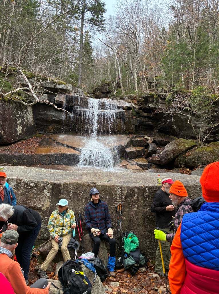
The first group arrived at the base of Champney and Pitcher falls at approximately 10:45 AM and the second group about 10 minutes later.
Everyone there enjoyed a snack and the views of the Falls taking several pictures. We took another mandatory group photo at approximately 11 AM and then continued up and around the Champney Falls loop.


Two of the hikers returned back down to the trail junction, where they waited for the rest of the group. The remaining hikers, and the dogs, ascended the steep and somewhat precarious stone stairway alongside the falls to the top of the falls and then descended back down the main trail completing the loop. The last stragglers arrived back at the parking lot by approximately 12:45 PM.


After breaking up at the parking lot, a group of five continued west on the Kancamagus Highway to Sabbaday Falls. This group included, Susan Sedita, Robin Marcelo, Kathy Huchthausen, David Atchason, and Gordon Farrell. This is a very busy and popular location as the hike into the Falls is only .3 miles.
The trail is wide and flat with only 101 feet of elevation gain. The water was flowing heavily and was an amazing sight! Well worth the additional short drive and hike.

Next Week’s Hike: October 31, 2025
Province Pond via Province Brook Trail, New Hampshire
Province Pond via Province Brook Trail is considered an easy hike that covers 3.1 mi, with an elevation gain of 413 ft. It takes about 1–1.5 hr to complete.
“Tucked away in a quiet corner of the White Mountain National Forest is a secluded mountain pond that is well worth a visit. Province Pond is a pretty little mountain pond in Chatham, NH. It is actually two ponds – the original glacial pond on the north end and a beaver pond on the south end. Don’t be discouraged at the first view of the pond’s boggy south end from the trail. This southern half of the pond is more wetland than pond with stumps and standing dead trees harkening back to when there was active beaver activity there. But follow the trail along the east side of the pond to the north end, and discover the deeper and lovely glacial pond. The north end also boasts a three-sided Adirondack-style shelter that sleeps six. It was built in the 1930’s and is maintained by the US Forest Service (USFS).
The New Hampshire Fish and Game Department (NHF&G) lists Province Pond as one of their backcountry trout ponds, twelve acres in size and with a maximum depth of ten feet. The deepest part of the pond is on the north end. The NHF&G regularly stocks it with fingerling brook trout. The NHF&G also built a timber crib dam on the south end of the pond in 1960 to stabilize the water level because of the beaver activity. In 2009 the USFS replaced the older dam with an earthen and concrete structure, including a concrete spillway.
Province Pond lies on the eastern edge of the 10,325-acre Kearsarge Inventoried Roadless Area. Dominating the skyline west of Province Pond are four small mountains – Mount Shaw (2,585 feet), the Twins (Gemini North at 2,519 feet and Gemini South at 2,490 feet) and Peaked Hill (1755 feet). The view across the pond to these small peaks is impressive. The mountains are an extension of the range extending northeast from Mount Kearsarge North. According to Steve Smith in his Mountain Wanderer blog, there was a network of trails on the Shaw-Gemini ridge in the 1930s and 1940s. These trails have all been abandoned for decades. There is an exposed ledge on the north shoulder of Mount Shaw. According to Smith there was a fire on the mountain started by a lightning strike many years ago (Smith quotes Dave Govatski, retired forester and fire officer from the White Mountain National Forest) and signs of the fire are still faintly visible.” Allen Crabtree
Champney Falls: a bit more history
There are two Champney Falls – a lower falls with a twenty-foot drop, and the upper section has a sixty-foot drop in a series of cascades, plunges, and a twelve-foot horsetail. Total height for Champney Falls is listed at seventy to eighty feet. Adjacent Pitcher Falls are about fifty feet.
Champney Falls were named for Benjamin Champney (1817-1907), a famous White Mountains landscape painter. Champney was born in New Ipswitch, NH, and began his training as a lithographer in Boston.
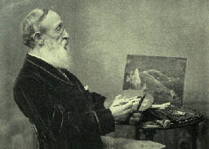
In 1853 he bought a summer place between Conway and North Conway where he lived for over fifty years. His enthusiasm for the area drew artists from all over the country and Champney is considered the founder of the “North Conway Colony” of painters who came to the area to paint the landscapes of the White Mountains in the latter half of the 1800’s.

Some of Champney’s more popular paintings included Glen Ellis Falls, Ripley Falls and Thompson Falls, and chromolithographs were often made from his more popular paintings for sale to tourists who could not afford Champney’s originals. Champney’s paintings are on display at the New Hampshire Historical Society and other galleries in the state and in Boston. He was a founder of the Boston Art Club.

Leave a comment