Hike Report – Shell Pond Loop – November 14, 2025
Thirteen Denmark Mountain Hikers met around 9:30 am at the gate that marks the boundary of the Stone House Property at the end of the Shell Pond Road in Evans Notch. The property contains a couple of houses and their outbuildings and a large cleared area, which includes an old airfield, that sits at the base of Blueberry Mountain. We have climbed Blueberry several times over the years often using the White Cairn and Stone House Trails that form a loop beginning and ending near the Stone House. For some reason, we have never done the Shell Pond Loop that is on private property and also begins and ends near the Stone House. Thanks to Sandy Bell, we have now added that hike to our repertoire.
Hiking today were Jeff Sturgis, Steve Kelley, Kathy Huchthausen, Gordon Farrell, Sandy Bell, Jean Murch, Robin Marciello, Phil Johnson, Dale Nelson, Susan Sedita, David Atchason, Allison Cooke and Toni Carros. We took our kiosk photo at the closed gate and headed up the road at 9:36 am.

After a short distance, we turned right onto the Shell Pond Trail heading counterclockwise on the Shell Pond Loop. The first portion of the trail goes around the southern side the pond on a fairly wide old vehicle trail. It rises and falls as it varies in elevation mostly above the pond. After about a mile, the trail turns to the left as it descends to the level of the pond and skirts the eastern edge of the pond.
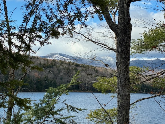
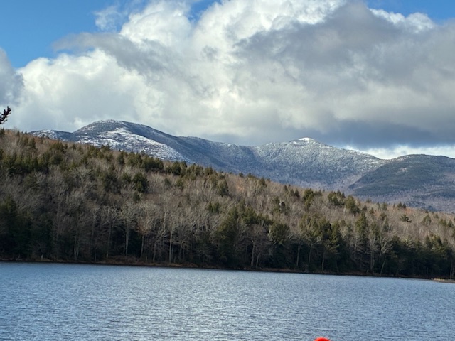
The weather was quite peasant and mostly sunny with temperatures in the upper 30’s, low 40’s, but when we came close to the eastern shore , the breeze picked up causing most of us to zip up and button our outer layer. There were several openings on the shore that allowed us to see the beautiful, snowcapped Baldface and Eagle Crag summits that were across the pond. Some of us gobbled down snacks or sandwiches at these brief stops. Around 11:00 am we arrived at a nice clearing that had a nice bench and extended down to the shoreline. It gave us spectacular views of these mountains that are across the notch on its western side.

About twenty minutes later, we arrived at the trail junction with the spur that goes off to the right to the Deer Hill Road that is not plowed in the winter. This junction marked the 1.9 mile length of the trail and indicated that we had .7 miles to go back to our vehicles.
After crossing Rattlesnake Brook and navigating a short muddy area, the trail opened to a beautiful grassy area that extends out from the Stone House and the old airfield. This area was open, but still had scattered trees and ran beside the brook. It appeared that much of it is mowed during the summer, and there was a woodshed and fire pit that indicated summertime activities occur there. Thus, the last half a mile of the hike was most pleasant as we reached the airfield and crossed it in front of the Stone House and the other buildings and the trailheads that are interspersed between them. Rattlesnake Pool is a short distance up the Stone House Trail and is a popular destination during the summer, but we opted not to pursue that option. We left the clearing, and a short walk along the road brought us back to the gate and our vehicles around noontime.
The Stone House was built around 1840 by Abel Andrews using granite blocks hewn from Rattlesnake Mountain. Abel (1807-1884), had settled there with his wife and thirteen children in the 1830s. Abel’s wife, Lucinda Brickett (1817-1884), was daughter of John Brickett of the so-called Brickett Place at North Stow. The homestead passed to Abel’s son Elden (1836-1914) and then to Elden’s son Ira Augustus (1863-1942), who sold it in 1917.
The story is that the Andrews womenfolk found the location too isolated. “Nothing to do but look at mountains.” They sold it to a lumber baron. The Cromwell/Landry family bought the farm from Saunders Brothers, a lumber company, in 1986.
In the 1940s, the area was used as a military airstrip for training exercises, and the flat, grassy field is still visible today.
Between 1951 and 1986 the land was owned by Saunders Brothers Company of Westbrook, ME, who built a private 1600-foot airstrip in the field south of the stone house. Saunders Brothers used the stone house as a hunting lodge for their employees and guests. In 1986, the property was purchased by David Cromwell. (Many of these details are from the Cold River Chronicle by David Crouse. Mr. Crouse was a local historian who began writing and publishing the Cold River Chronicle three or four issues per year starting in the Spring of 1993 ending in 2024. His articles cover ther history of Stow, Lovell, Stoneham, Fryeburg and Chatham NH. Mr. Crouse passed away March 9, 2025.)
Today, the Stone House farm property, though still in private ownership, is protected through a conservation easement which the owners gifted to the Lovell Land Trust. The land is protected from future development that allows traditional public uses such as hiking and hunting..
This was a very nice hike and some of us wondered how it had escaped our notice over the 15 years of our existence as a hiking group. However, it will now be firmly added to our inventory, as many of us cannot wait until we return again to enjoy this beautiful trail.
NEXT WEEK:
Shepard’s Farm on November 21, 2025
November 21-Easy – Shepard’s Farm Preserve (1,061 ft), Norway, ME – 3.4 mi RT, 226 ft elevation gain. RT hiking time 3 hours. RT driving 1 1⁄2 hours.
We will leave from the Half Witt Trailhead that is about a mile down Pleasant Street from its intersection with Main Street in Norway. Please note that you should go past the Witt Swamp Trailhead that is about a half mile down Pleasant Street and continue further to the Half Witt Trailhead. There is no parking lot as the parking is along the road in front of the trailhead. We’ll begin by crossing the swamp on an extensive boardwalk. Then we’ll hike to the field that has the well-known Bernard Langlais sculptures. Returning to the boardwalk, we’ll have a choice of taking a two mile loop that circles the swamp or retuning to our vehicles on the boardwalk. A map of the preserve and trails can be downloaded here
TAKE NOTE: Jeff will go directly to the trailhead and not to the church. So those who meet at the church to carpool should follow the same procedure and leave, as usual, at 8:30 am.

Full map is at: https://www.wfltmaine.org/_files/ugd/0bda31_38f7f1065081439c9a5d0eb235a08a73.pdf

Leave a comment