Hike to Five Kezar Ponds
June 5 – Moderate – 3 mi RT, 600’ elevation gain, RT hiking 3 hrs, RT driving 1 1/2 hrs
Meet at the Denmark church at 8:30 am.
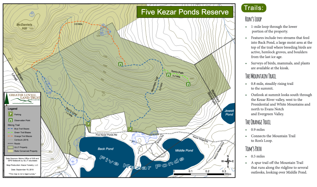
This week’s hike will be at the Greater Lovell Land Trust’s property known af Five Kezar Ponds. The ponds will be below us while we navigate the heights of their preserve. There are two trailheads in the preserve just 0.3 mile apart. Our plan is to park in the one to the east and if we run our of space to put a few cars in the west lot. Both lots are on Five Kezar Ponds Road. The east lot is the trailhead for the Mountain Trail. The west lot is the trailhead for the Ron’s Loop Trail. Starting from the east lot we will hike counter clockwise up the Mountain Trail, and over the high point and come down Ron’s Trail. I believe but am not certain that the coordinates of the west lot are HERE. and that the east lot is 3/10th of a mile closer and approximately at 44.212587, -70.811067. [This is when you say, “Don’t believe everything you read online.]. Written directions from Dale Nelson will follow and may prove more reliable.
Directions to the Trailhead:
From North Waterford, begin at P & Kay’s gas station on Route 5. turn right onto Route 35 (Valley Road), then right again onto Five Kezars Rd. At almost 2 miles turn right onto Kezars Ridge Road, and follow this road for about 0.6 miles. Shortly thereafter a sign marks the first GLLT trailhead, with the trailhead for Ron’s Loop being another 0.5 miles down this road.
From Denmark, follow rte 117 through Bridgton and turn left on Rte 37 by Bridgton Academy. Go left on Rte 35 in Waterford and when opposite the former Melbys in North Waterford (which sadly closed in September 2022), turn left on Five Kezars Rd. Then follow the directions above to the trailheads.
The mileage to the Kezar Ridge Road from the former Melby’s market is spot on and it’s signed. Then the mileage to the first trailhead is .9 miles on the Kezar Ridge Road and the mileage to the second trailhead is .3 miles. Just before the first trailhead the road does fork and we need to bear right where there are tons of camp signs on a tree. Seeing there is more parking at the first trailhead we will park there and hike counterclockwise and then walk the .3 back to our vehicles.
It’s about a forty minute drive from Denmark to the trail so if meeting the group at the trailhead, assume we won’t get there until 9:10. am assuming we can follow the directions.
NOTE: Dale doubled check the directions earlier this week and adds in his scouting report: “Judging by the amount of black flies bothering me this morning at 46°, I strongly suggest bug dope and nets.”
In an earlier hike announcement, we had mentioned that Polly was contemplating bringing kayaks to paddle on the lakes after we finish this hike. Wiser minds have prevailed and curbed her enthusiasm. Instead we will discuss organizing a separate paddle day in the near future. These ponds are notable as power boats are prohibited on them.
Below is a link to updated versions of last week’s hike reports. The earlier version sent out lacked some the excellent photos that Laura shared with me and I accidentally deleted.
Hike Report Hermit Falls and Speckled Mtn..
(Jacob Schor)

Leave a comment