It feels like I’ve scrambled up several attempts so far to tell you where the hikes are going next week so let me start from scratch. Hopefully straighten out the confusion….
There are two hikes this coming Friday.
A hard hike up Caribou mountain. There is an excellent description of this hike at https://www.maine.gov/dacf/mnap/assistance/hikes/caribou.pdf
Caribou Mountain is a scenic 2,828-foot peak located in the Evans Notch region of the White Mountain National Forest within the Caribou-Speckled Mountain Wilderness in Maine.
Trailhead: Located off State Route 113 in Evans Notch.
The main parking area for Caribou Mountain is the Caribou West / Mud Brook Trailhead, located directly off Maine State Route 113 in the White Mountain National Forest.
- Trailhead Name: Caribou West / Mud Brook Trailhead
- Coordinates:
44.3315, -71.0118(Type this directly into Google Maps or Apple Maps) - Parking Fee: A White Mountain National Forest day pass or recreation fee may be required.
- No Cell Service: Cellular coverage is completely spotty to nonexistent throughout Evans Notch. Download your offline maps, coordinates, and trail guides before leaving home. Of course a similar reminder applies to Denmark and the church parking lot.
OR:
The Easy Hike– Shell Pond, Lovell, ME – 2 mi RT, 187’ elevation gain. RT hiking 1.5 hr. RT driving 1.5 hours.
We last went to Shell pond last November at Sandy’s insistance. We liked the hike so much that we are going back. (Going back has nothing to do with my missing it the first time we went.) We are going to access the trail from the Shell Pond Rd trailhead. Here are driving directions that seemed to work last year to get everyone there: https://denmarkmountainhikers.com/824-2
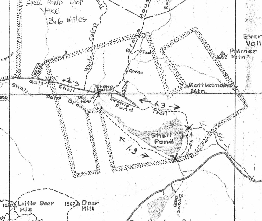
Just to be sure I’m going to paste those directions here: they even come with an artistically hand drawn map
Travel north on Rte. 113 towards Evans Notch. The Stone House Road is the first marked town road after the parking lot for the Baldface Loop Trailhead. Turn right and follow the road to the end where there is a closed gate. The parking area is to your right.
The Hike: 3.6 miles from and to the gate. Elevation gain estimates vary from 171 to 300 feet.
Pass through the gate and follow the road for .2 miles to the Shell Pond Loop Trailhead on your right. The trail passes through a meadow and along the river, to a bridge crossing the Shell Pond Brook, and then swings left on a well-worn woods road. It traverses the slope above the south shore of Shell Pond. At 1.3 miles the trail turns left off the road and descends, meandering through the woods behind the east shore of the pond, and crossing several small brooks. At 1.7 miles a spur leads to a clearing and a view of Baldface across the pond. The main trail then bears right and meets the Shell Pond Trail at 1.9 mile. The trail turns left, broadens and runs alongside the base of Rattlesnake and Albany Mountains. The trail crosses a bridge over the Rattlesnake Brook and continues along the brook and through an orchard. Eventually the trail opens to an airfield with a view of the Stone House on the right. At 3.4 miles the trail returns to the Shell Pond Loop Trailhead after passing two trails leading to Blueberry Mountain on the right. The gate is straight ahead.
I’m going to try and post this quickly before my computer loses its internet correction again and I lose this draft version once again.

Leave a comment