October 9 – Moderate – Mount Potash (2,700 ft.), Kancamagus Hwy, NH. 3.5 mi RT, 1,400 ft. elevation gain. RT hiking 2.5 hours. RT driving 2.5 hours. (HL – Gordon)
Mount Potash (also known as Potash Mountain) is a 2,680-foot peak in the White Mountain National Forest of New Hampshire, offering 360-degree summit views as part of the popular 52 With a View hiking list.
- Location: Off the Kancamagus Highway (Route 112), across from the Passaconaway Campground near Wonalancet/Conway, New Hampshire.
- Trail Length: ~4.0 to 4.2 miles round-trip (out-and-back).
- Elevation Gain: 1,387 to 1,400 feet.
- Estimated Time: 2.5 to 3 hours.
- Difficulty: Moderate, featuring a gentle start that turns steep with rocky and root-heavy terrain near the top.
Trail Details
- The Trailhead: Begins from the Downes Brook Trailhead, which also accesses neighboring Hedgehog Mountain.
- Water Crossing: The route requires a crossing of Downes Brook near the beginning.
- Views: The open summit ledges provide expansive vistas of Mount Passaconaway, Mount Whiteface, the Tripyramids, and Mount Washington on clear days.
The Name’s Origin
In the 18th and 19th centuries, early New England settlers cleared dense hardwood forests for agriculture. They burned the logged timber and collected the resulting wood ash. By leaching the ash with water and boiling the liquid down in massive, heavy iron cauldrons, they produced potash (potassium carbonate)—America’s first industrial chemical export, highly prized for making soap, glass, and fertilizer.
The rounded dome profile of the peak reminded early surveyors and locals of one of these large, upside-down manufacturing kettles.
History of the Name:
Mid-1870s: The name gained official scientific tracking when Prof. Charles H. Hitchcock utilized it during his comprehensive geological survey of New Hampshire.
- 1876: Renowned travel writer Moses Sweetser published a prominent guidebook noting that Mount Potash was “easily visited” by travelers venturing into the scenic Albany Intervale.
- Early 1900s: The peak became famous for a unique “balanced rock” located on the southeast side of the summit area. In the early 20th century, hikers could easily rock the massive boulder back and forth with their hands, though subsequent trail realignments and natural shifting eventually left the rock more solidly situated and hidden from the modern main path.
Today, the official U.S. Geological Survey (USGS) maps label the peak as “Potash Mtn.,” while the path leading hikers up to its 360-degree views remains standardly known as the Mount Potash Trail.
Trail Map https://www.trailfinder.info/trails/trail/mount-potash
Trailhead directions:
From Conway: Follow the Kancamagus Scenic Byway (NH-112) west for 14.2 miles, and turn left for the Downes Brook Trailhead, across from the Passaconaway Campground.
- Trailhead Parking: Located at the end of a very short gravel access road on the south side of the Kancamagus Highway (NH-112) in Albany, NH.
- The Campground: The trailhead parking lot sits directly across the highway from the Passaconaway Campground and Passaconaway Historic Site. [
- Starting the Hike: You will begin walking on the Downes Brook Trail from the parking lot. After about 150 feet, pass the UNH trail split, stay right, and follow Downes Brook Trail for about 0.4 miles before veering right onto the official Mount Potash Trail.
The GPS coordinates for the Downes Brook Trailhead parking area (which serves as the main trailhead for the Mount Potash Trail, UNH Trail, and Downes Brook Trail) are:
- Decimal Degrees (DD): 43.994200, -71.369317
- Degrees, Minutes, Seconds (DMS): 43°59’39.1″N 71°22’09.5″W
- GPS Coordinates Format: N43° 59.652, W071° 22.159
Potash Cauldrons seem to look rather like the classic image of a witches cauldron, think Shakespeare or Halloween kind of cauldron. However the classic illustration does look much flatter, the better to evaporate the water off of the ashes:

Recipe for American Potash Cake:
[circa 1799]
[note I haven’t tried making this yet]
Yanking Out Invasive Bittersweet on Bald Pate Mtn:
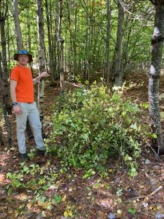
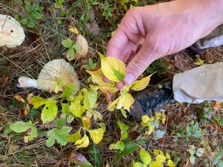
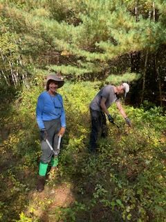
Three Denmark hikers (Greg Dean, Bev Reid, Jacob Schor, the later apparently by accident) along with a hand full of other volunteers showed up at the Bald Pate parking lot last Thursday and under the direction of Rhyan Paquereau from Loon Echo Land Trust learned how to recognize Oriental Bittersweet (Celastrus orbiculatus ) that had been spotted growing up on one of the trails last August by a volunteer trail Ambassador. These plants have been migrating north from Massachusetts and have been spotted in the Peabody Pont area. Maine classes them as Severely Invasive.
https://extension.umd.edu/resource/oriental-bittersweet
These plants were imported in the mid 1800s from Asia as an ornamental garden plant. It seems that was a mistake to have done.
The Hike Report for Oversett is still in process and should be done early in the week.

Leave a comment